The Manaslu Trek loops around Mount Manaslu (8,163 meters), the world’s eighth-tallest mountain. The journey begins in Kathmandu and winds through mountain villages, over high passes and through gorgeous valleys. Larkya La Pass (5,106 m) is the highest point of this trail, from where you will witness the close-up sights of the mighty Himalayas. This blog walks you through the full route, key stops, and how the trek comes together from start to finish. You will know where you go each day, and why each landmark around the Manaslu region is significant.
Manaslu Trek Route Map: Full Breakdown & Key Stops

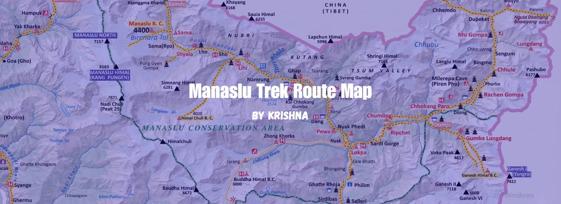
Manaslu Trek Route Map
The Manaslu Trek route map shows the trail and journey you take on this mountain adventure. You must know the route and other essentials before you commence trekking.
A route map informs you where to go every day. It shows major landmarks like villages, rivers and mountain passes. It’s what allows you to get perspective on your journey, and it's best for first-time trekkers and those who want clarity on the route. It is helpful for those organising their trek and considering whether or not this is the trip for them.
The Manaslu Circuit Trek is a favourite among people looking for something that’s not like other treks in Nepal. You will be in the untouched places around Manaslu, where very few tourists visit. You trek through traditional villages and over high mountain passes with Mount Manaslu coming into view from countless angles.
This guide tells the route in very simple terms. We’ll tell you where the trek begins, ends, what all the key stops are and how things flow between them. You will see the whole long road before your mind at last.
Where Does the Manaslu Trek Start and End?
The Manaslu Trek has a clear starting and ending point. Understanding this helps you plan your journey.
Starting Point:
You begin the hike from Machha Khola (930 meters), after you drive there from Kathmandu. The drive is 7 to 8 hours by jeep, and you go through big cities first before heading up into the mountains. When you arrive at Machha Khola, the walking starts. This is where your feet hit the mountain trails for the first time.
Others drive on to Soti Khola (730 meters) before further driving to Machha Khola. That is where we might begin in the modern age, because roads are much better now. The journey actually begins when you get out of the jeep and hike up a hill.
Ending Point:
The trek ends in Dharapani (1,860 Meters). Dharapani is even bigger than where you began. You drive to Kathmandu or Pokhara from Dharapani, which is a 6 – 8 hour drive. When you arrive at Kathmandu or Pokhara, your trek will be completed.
Connection to Annapurna:
Dharapani is the connecting point of the Annapurna Circuit Trek, which is another interesting thing about it. A lot of hikers do both treks, completing the Manaslu Circuit, then going straight into the Annapurna Circuit from the same location. So Dharapani happens to be like a junction between two big trekking routes in Nepal, and many trekkers choose the Manaslu With Annapurna Circuit Trek for a longer and more adventurous journey.
Key points to remember:
- Trek starts: Machha Khola (930 meters)
- Trek ends: Dharapani (1,860 meters)
- Direction: Circular loop around Mount Manaslu
- Total altitude gain: Starting at 930m, going up to 5,106m, and coming down to 1,860m
Complete Manaslu Trek Route Overview (Day-wise Flow)
Manaslu Trek has its own route. Here’s how you navigate from day to day. Every day lists where you are hiking, how high it is and what the trek over the passes looks like.
-
Day 1:Kathmandu to Machha Khola. Drive through Soti Khola. The highway runs alongside the Trishuli River. In the evening, you arrive at the point where you will start.
-
Day 2:Machha Khola to Jagat. Hike 22 kilometres following the Budhi Gandaki River. You travel through forests and tiny towns. Trekking Day 1 : This is your first trek day, to acclimatise for the rest of the trek.
-
Day 3: Jagat to Deng. Hike 16 kilometres uphill through wooded terrain. You enter the restricted area. First glimpse of Manaslu peak is sighted. This is where the mountains become taller.
-
Day 4: Deng to Namrung. Hike 12 kilometres through mountain villages. You will pass teahouses and small settlements on the way. The altitude is higher now (2,630 meters).
-
Day 5: Namrung to Lho. Trek 20 miles to Lho village. The air becomes thinner. More mountain peaks are visible all around you. Altitude: 3,180 meters.
-
Day 6: Lho to Samagaon. Hiking the main trail to: The main village, Samagaon (3,505 meters); Trek 11 kilometres. It’s the largest village on the trail. This altitude makes this spot popular for trekkers to acclimatize.
-
Day 7: Acclimatisation day in Samagaon. No trekking today. Best advice from your Mountain. Savvy guide: Take it easy, and give your body time to acclimate to high altitude. You can amble easily to a nearby monastery. Tiredness is common for many trekkers, so of course, stop and rest.
-
Day 8: Samagaon to Samdo. Walk 8 km to Samdo (3,875 m). This village is the highest on the trek. The route goes through yak pastures. Not too many trees here, mostly open land.
-
Day 9: Samdo to Dharamsala (Larkya Pedi). Trek 10 kilometres to Dharamsala (4,460 meters). This is a final station before the pass. Very few people live here. It gets really cold up here.
-
Day 10: Dharamsala to Larkya La Pass and down to Bhimtang. This is the biggest day. You walk 15 kilometres. Ascend to Larkya La Pass (5,106 meters) and backtrack down to Bhimtang (3,590 meters). This day takes 7–8 hours. You begin in the dark, and you climb the whole day.
-
Day 11: Bhimtang to Tilche. Trek 14 kilometers down past lovely forests. You see rhododendron trees here. The air becomes thicker. The lower you go, the better it feels for your body.
-
Day 12: Tilche to Dharapani
-
It's the final day of trekking. You reach civilization again. From there, it is a drive to Kathmandu or Pokhara.
Most trekkers follow this basic route. Some days you might be a bit shorter or longer based on your fitness. The walking is about 160 kilometres overall over 12 days. The highest spot — Larkya La Pass — occurs on Day 10.
Key Villages and Stops on the Manaslu Trek Route
The Manaslu Trek passes through many villages. Each village is important for different reasons. Here are the main stops:
Machha Khola (930 m)
Machha Khola is the starting point of your trek, a little town in the hills of Gorkha. As you arrive at Machha Khola, you will come across local stone-and-wood houses. The village has a number of teahouses, where trekkers sleep at night. Machha Khola is also a spot that offers a transition from the smooth ride to a hike to the Manaslu Circuit.
Jagat (1,340 m)
Jagat is a classic rock village, which is the official check post to enter the Manaslu Conservation Area. Your permits are checked by the authorities here since this is where you officially get into the National Protected Mountain Area. From local culture and traditional architecture in the village to the natural wonders like the clear view of Mount Ganesh Himal, you can enjoy every bit of your stay in Jagat.
Deng (1,860 m)
Deng is a small village where the terrain shifts from lush green landscapes and the mountains get real now. Though the forest gets thicker, Manaslu Peak is clearly visible from here. There are a few tea houses in Deng, where trekkers spend their night after a long hike.
Namrung (2,630 m)
Namrung is a picturesque Tibetan village, where houses have flat roofs, showing the characteristic of Tibetan-style architecture. It is the entry to the highest level of the trek from where trekkers can have the magnificent views of Manaslu and Himchuli. From here, altitude begins to take its toll on a lot of trekkers.
Samagaon (3,520 m)
The trail passes through the most important village on this track, Samagaon. It lies at an elevation of approximately 3,530 meters above sea level in the Budi Gandaki Valley. It is also a great vantage point from where sightseeing of Mt. Manaslu and Himchuli come with a cinematic view. Surrounded by lofty peaks and lush green forests, Samagaon is one of the beautiful spots to stop during the Manaslu Circuit Trek.
Samdo
Samdo is a high altitude village located at 3,875m on the Manaslu Circuit Trek in Nepal, close to the Tibetan border, and this small city would be your last permanent settlement before crossing Larkya La Pass. It was founded by Tibetan refugee settlers and has strong Tibetan cultural and Buddhist practices reflected in its stone houses, prayer flags, mani walls and small monastery.
The people of Samdo live by herding yaks, dependent on the generosity of passing trekkers. The village has teahouses, so don't worry about food; you will have lunch in Humde, with dramatic views of Manaslu and its neighbouring peaks. Samdo also serves as an essential acclimatisation rest point on the section east of Annapurna.
Dharamsala/Larkya Phedi(4,460 m)
Dharmashala (Larkya La Phedi or Larkya Phedi) is a high altitude settlement situated at about an elevation of 4,460 metres on the way to the Manaslu Circuit trek. It is situated between Samdo and the Larkya La (5,106 m), making it the last village before the tough pass. The place has an ordinary teahouse-type of lodging with a minimum set-up, simple local food and no western conveniences. It provides a stunning Himalayan panorama and crucial sleep and acclimatisation prior to the climb, especially for trekkers doing the Manaslu Circuit Tsum Valley Trek.
Larkya La Pass (5,106 meters): The Highest Point on the Route
The Larkya La is the highest point of the Manaslu Circuit, one of the classic treks in Nepal and heading towards the Annapurna region, with an elevation of 5,106 metres (16,750 ft). It is one of the most important, and certainly one of several most difficult parts within your trek and well gained popularity for its steep climb, high elevations & mind-blowing Himalayan sights.
The crossing of Larkya La is a highlight, rewarding trekkers with magnificent views of snow-capped peaks, glaciers, and sweeping valleys - including the north face of surrounding summits such as Himlung Himal and Kang Guru.
With its altitude, thin air, and unpredictable weather, the pass is a challenging yet highly cherished accomplishment for prepared hikers. It takes us through uninhabited valleys and traditional Gurung/Tibetan villages with a cultural richness as well as a European type of beauty.
The Manaslu Circuit Larkya La Pass is a physical accomplishment as well as an unforgettable landmark in any Himalayan adventure.
How Do Trekkers Cross It?
Trekkers tend to cross the Larkya La Pass in the morning, because it is less likely to be affected by strong winds or changing weather conditions typical of high elevations. The day starts early, before sunrise, from Dharmasala (Larkya Phedi), with an easy climb up a glacier moraine, continuing to the rock-made path, and snow-covered trails , depending on the season.
It’s a long grind to the top, so be patient here and establish a good acclimatisation rhythm. There is also a significant amount of snow and ice on the trail, so bring trekking poles, dress in layers and maybe even wear microspikes for extra grip.
Resting at the prayer flag fluttered past after reaching Larkya La, hikers take in views of the Himalayas before descending for hours to Bimthang — having successfully crossed over the pass.
Manaslu Trek Route Map with Optional Side Trips
There is always a provision of extending your adventure. And many trekkers choose to extend the Manaslu Circuit by adding optional side trips, allowing them to explore additional landscapes and cultural sites beyond the main route.
Side Trip to Manaslu Base Camp
Manaslu Base Camp is a common side trek for trekkers looking to see Mount Manaslu up close. At 4,820m, this side trip usually takes two additional days. The trek is from Samagaon with a trek back to the same village. (Manaslu Base Camp is where climbers make the starting point for climbing, and it hasn't seen many more trekkers visit this site except those who deliberately plan to side-trip.)
Cultural Side Trips
Cultural side treks introduce trekkers to the indigenous culture of the Manaslu region. Trekkers can explore nearby monasteries and traditional villages, like the Guru Rilva Monastery at Samagaon. While there, you have the chance to meet some monks who live there and learn about Buddhism. Sightseeing tours will typically add one to two days onto the schedule.
Side treks are frequently undertaken by some trekkers who have more time to spare or wish to acclimatise better. The regular Manaslu Circuit itinerary lasts for approximately 12 days, though side excursions may stretch the trek to about 14–16 days. All side trips are optional and are separate from the main walking trail.
How the Manaslu Route Connects to the Annapurna Circuit
The Manaslu Circuit Trek and the Annapurna Circuit Trek are distinct routes; however, they are directly connected, offering trekkers valuable flexibility in itinerary planning.
Where the Routes Meet
Dharapani is the key junction where the Manaslu Circuit and Annapurna Circuit meet, making it an important confluence point for trekkers. From here, the eastward Manaslu route connects smoothly with the westward Annapurna trail. This link creates the popular Manaslu With Annapurna Circuit Trek, allowing trekkers to experience both iconic Himalayan routes in one journey.
This link is especially beneficial to those who wish to do the 2 treks simultaneously in a single trip. Trekkers can start from either Manaslu or Annapurna, as per their wish and availability of time. Some trekkers opt to do the complete loop as one longer trek, usually taking about 22–24 days, rather than doing two separate circuits of 10dayseach.
Exit and Continuation Options
From Dharapani, trekkers can decide to either end their trek or continue further. One alternative is returning to Kathmandu by overland (6–7 hours) drive. Either that or trekkers may also move directly to Besisahar, which is some 5-6 hours drive away from Kathmandu; it’s a usual commencement point of Annapurna Circuit. This is where you start the Annapurna Circuit if you go on after completing Manaslu.
These are two of the best-known treks in Nepal, and they are very close to one another, making for a great combination and an excellent opportunity to create the ultimate Himalayan adventure.
Best Way to Read and Use the Manaslu Route Map
Understanding how to read and interpret the Manaslu route map is essential for effective planning and a smoother trekking experience.
Understanding Distances
Trekking maps show the distances between villages according to the trail length. Ground distances are often longer and more challenging because the trails go up and down rolling landscapes. For comparison, a six-miles distance usually means 3–4 hours hike at high altitude and above; surely this depends on the trail and personal walking speed.
Importance of Guides and Trail Markings
The guides are all licensed and indispensable navigators. They both know the road like the back of their hand and, at times, they follow instinct as much as the map.
Besides, there are stone slabs, painted signs and direction boards which point at the villages and distance en route. The main trail is well-marked; however, some branches come off the trail in places. You'll always be led the right way with a guide.
Using Maps During the Trek
It is a good idea to have a small map or guidebook on the walk. Take a look at the map during rest or while eating, keep track of where you are and what the next section has in store, both for villages/towns, but also for an up or down elevation. This increases your mental preparedness as well as provides you with a good knowledge of the geography of the area. It’s also useful to take a daily picture of the map pages.
Elevation marks are available on trail maps. To monitor these ascents means you can calculate the amount of height gained daily, help plan your acclimatisation better and avoid altitude-related problems.
Final Route Summary & Planning Tips
The Manaslu Circuit Trek is an adventurous journey around the Manaslu region that begins and ends in Machha Khola (930 m) and Dharapani (1,860 m), respectively. The peak of the trek is Larkya La pass, 5,106 m. The trail goes through several important settlements and requires 5 to 8 hours of daily walks across a diverse (and occasionally difficult) landscape. This trek is challenging but feasible for trekkers with good physical fitness and some high-altitude experience.
This is a trail for trekkers who already have prior trekking experience and want something more off the beaten track. It’s perfect for hikers who like solitude, mountainside culture and fewer people around.
Proper planning is essential. Scout the route session when they should come up to speed, and in advance get all permits, arrange camp accommodation/gear hire (or join an open group), secure appropriate travel insurance and kit themselves out correctly. Knowing in advance about the trail makes you feel more secure and helps you handle your daily plans better, ensuring a trouble-free trekking experience.

Need Help? Call Us.+977 9851230809