- The Larke Pass route is the highest and most challenging section of the Manaslu Circuit Trek.
- The trail links Dharmasala (Larke Phedi, 4,460 m/14,632.55 ft) to Bhimtang, offering breathtaking views of the peaks: Mt. Manaslu, Himlung, and Cheo Himal.
- Must have proper acclimatization and physical fitness to cross the pass safely.
- The weather is unpredictable at high elevations, even during the peak trekking season. Hence, choosing the right time of year by checking the weather forecast for your travel dates when planning and hiring a guide is necessary.
- The trail is challenging but rewarding in the end if it’s done with proper planning and preparation.
Larke Pass Route

Larke Pass Route
The Larke Pass route is the toughest yet most exciting section of the Manaslu Trek. It’s the highest and main point of the journey, reaching an altitude of 5,106 m (16,751. 97 ft), offering breathtaking landscapes and raw Himalayan beauty, including Mount Manaslu (8,163 m/26,781 ft), the world’s eighth-highest peak.
It’s one of the dream trails for most trekkers. The journey is challenging; nonetheless, you’ll enjoy the most stunning panorama of Himlung Himal (7,126 m/23,379.27 ft), Cheo Himal (6,820 m/22,375 ft), and other peaks, alongside Mt. Manaslu, as a worthy reward when crossing it.
During the trek, you’ll hike through calm forests, glacial valleys, and wide alpine landscapes. The scenery keeps changing as you move further, increasing your excitement and giving you a sense of triumph.
Along with beautiful mountain views, you’ll also experience the rich culture as you pass through the villages, highly influenced by Tibetan Buddhism. You can visit ancient monasteries on your acclimatisation day during the trip. Also, the warm hospitality of locals makes it even more special.
Trek Overview & Route Map
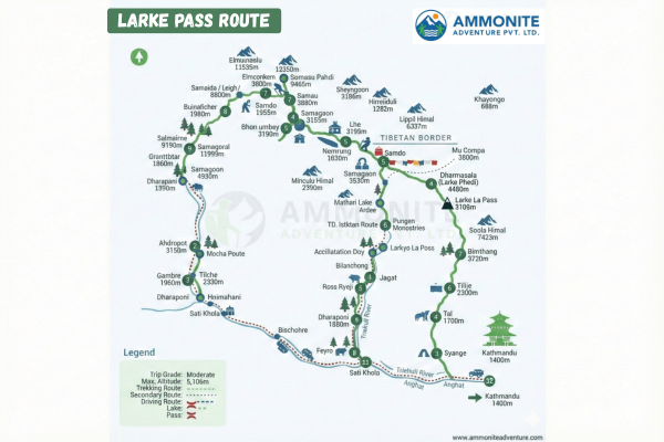
The Manaslu Trek generally begins in Soti Khola or Machha Khola and concludes in Dharapani. The trekking route goes through some beautiful villages: Jagat, Deng, Namrung, Lho, Samagaun, Samdo, and Bhimthang (by crossing Larkya La).
Among these villages, Samagaun and Samdo are typical points for acclimatization. However, most trekkers spend an extra day in Samagaun and then head straight to Dharmasala before the Larke pass for the important overnight camps. After crossing the pass the next day, Bhimtang is another key stop for an overnight, as you walk around for 8 hours that day.
Speaking of the duration, it depends on acclimatization and walking pace. Nevertheless, the journey can be finished normally in 14 days. You’ll hike for 5 to 7 hours through stunning villages, forests, and high alpine terrain each day. The Manaslu Circuit Tsum Valley Trek is an extended version that includes additional cultural exploration in the Tsum Valley, making the overall experience more immersive and longer in duration.
A trail map assists you in learning about day-to-day distances, altitude gain, and village locations. Therefore, we provide you with it so that you can plan your trip accordingly. Here it is below:
Trek Duration & Difficulty Level
As stated earlier, the duration of the Manaslu Circuit Trek is usually 14 days, depending on how many places you spend an extra day for acclimatization and walking pace. On the other hand, it’s overall moderate to challenging in difficulty.
Daily Difficulty Overview
In the lower sections of the trekking route, from Soti Khola to Lho, your daily hike isn’t that hard. However, once you reach the upper sections, from Samagaun to Larkya La Pass, the difficulty level increases. Not because the trail is technically demanding, but because of the altitude gain.
Fitness Level Needed
Since the trek is moderate to challenging, it’d be beneficial to have a good fitness level. If you aren’t a regular workout person, you should start doing it at least a month before your journey for an hour every day. Consider doing exercises such as stretching, squatting, running, cycling, and swimming.
Seasonal Conditions
The difficulty of the Manaslu Trek is also defined by the season you choose to go. The best time for trekking is during spring (March to May) and autumn (September to November). The other two seasons: winter (December to February) and monsoon (June to August) are considered off-seasons due to harsh weather conditions.
Below is the season-wise breakdown of the weather conditions and difficulty level:
- Winter: Frigid temperatures at night and in the early morning, shorter daylight hours, and a high chance of heavy snowfall at higher altitudes. Challenging.
- Spring: Mild temperatures, longer daylight hours, and clear views. Moderately difficult.
- Monsoon: Heavy rainfall (especially at lower altitudes), slippery and muddy trails, Leech bites in grassy areas, and the risk of landslides and floods are high. Very challenging, not recommended.
- Autumn: stable weather and clear views. Moderate to challenging.
Difficulty Scale
| Level | Note |
| Easy |
Plain route, low elevations. |
| Moderate |
Uphill hike, elevation more than 3,000 m (9,842.52 ft). |
| Challenging |
Rocky or steep, altitude gain 4,000-5,000 m (13,123.36-16,404.2 ft) |
|
Extremely Challenging |
High passes (5,000 m), thin air, and freezing temperatures. |
Check the blog for preparation of the Manaslu Circuit Trek.
Permits & Regulations
To cross the Larkya La Pass safely and legally, four different permits are required, which can be obtained by providing a passport, passport-sized photo, and your group details to local tour operators. These required permits are listed below:
Manaslu Restricted Area Permit (RAP)
The region falls in the restricted area because it’s close to the Nepal-China border and is home to Tibetan Buddhists. So, to control the flow of tourists in such a fragile zone and protect the culture, RAP is required. Its fee is around USD 210 per person for any nationality.
Manaslu Conservation Area Permit (MCAP)
The trekking route lies in the Manaslu Conservation Area, which is why MCAP needed to protect the natural environment, conserve endangered species, help maintain trails, and promote sustainable tourism in the area. It costs approximately USD 8 per person for SAARC nationals and USD 23-30 per person for others.
Annapurna Conservation Area Permit (ACAP)
After crossing the pass, you’ll enter the Manang District, which is part of the Annapurna Conservation Area. You commence your journey in the Manaslu Region but conclude in the Annapurna. Therefore, ACAP is needed, which costs the same as MCAP.
Trekkers’ Information Management System (TIMS)
TIMS is required to help the government track your movement on the trail, record your entry and exit, make the rescue team aware of your last location in case of emergencies, and promote sustainable tourism. It costs around USD 15 per person for SAARC nationals and USD 20 per person for others.
Altitude Sickness & Safety Tips
Since the Larke Pass rises to 5,106 m (16,751.97 ft), without a shadow of a doubt, altitude sickness is common at such a height. It usually starts happening once you reach 2,500 m (8,202.1 ft). Its symptoms are as follows:
- Headache (the most common one).
- Nausea or vomiting.
- Insomnia or trouble sleeping.
- Loss of appetite.
- Fatigue or unusual tiredness.
- Dizziness.
To prevent altitude sickness and cross the pass successfully, you need to focus on these safety tips during the Manaslu Trek:
- Control your walking pace. A gradual ascent with frequent breaks of at least five minutes is the best practice.
- Spend an extra day at the same place once you make it up to 3,000 m (9,843 ft) to acclimate your body.
- Drink at least 3 to 4 litres of water every day to keep yourself hydrated. Also, consider eating an apple and a cucumber a day, because they also contain water.
- Focus on consuming mostly carbohydrate foods, such as rice, pasta, potatoes, lentils, and bread, because they contain a high level of calories, keeping you energised for a long time.
- Consult a doctor about your current health condition and buy acetazolamide (Diamox), the best medication for altitude sickness, under their prescription before going on the trek.
Conclusion
The Larke Pass route is the most adventurous and challenging section of the Manaslu Trek, with beautiful landscapes, panoramic views of Mt. Manaslu and neighbouring peaks, and rich Tibetan Buddhist culture as a worthy reward. The journey is moderate to challenging due to its elevation gain and long duration; nonetheless, good acclimatization, fitness, and planning can make it successful.
Prepare required permits prior to trek and plan for either the best times, spring or autumn, for better results. Crossing the pass will become an amazing Himalayan experience with proper preparation, safety tips, and a professional trekking guide. For another high-pass trip, you may also try the Annapurna Circuit Trek.

Need Help? Call Us.+977 9851230809