What is Kala Patthar & Why It Matters
Kala Patthar means "Black Rock" in the local language. It appears as a dark hill from below and is located below the large, pyramid-shaped, snow-capped summit of Pumori. It's a broad black shale outcrop with numerous boulders. Even in bright sunlight, it's frequently very windy at this ridge. And wind chill makes the air feel even colder than the actual temperature. You'll want to pack an extra layer for this one.
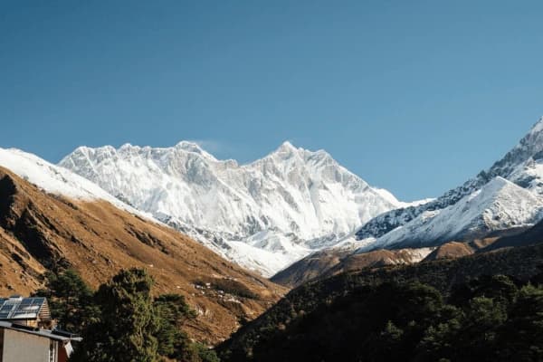
Many hikers don't realise until they arrive at base camp that you cannot see Mount Everest's summit while standing on the glacier at Everest Base Camp. Because of the orientation of other peaks, when looking towards the summit of the world's tallest mountain, you are actually looking over the southwestern shoulder of Nuptse.
So the first real view of the summit of Everest is at Kala Patthar's true summit. And this is where many of the iconic postcard images of Everest's summit actually originated.
Kala Patthar is located at an elevation of 5,545 m (18,192 ft) with a higher ridge peak of 5,644 m (18,519 ft). At this height, oxygen is about 50% of what it is at sea level. So every step feels like a strenuous workout compared to sea level. Even our strongest athletes have been observed breathing heavily at this elevation. You'll feel it too.
Kala Patthar provides the closest and most impressive view of the Khumbu Icefall. It's particularly striking on the South Col route where climbers make their way to the summit. It's a remarkable place. And the best time for photographyis sunset as opposed to sunrise. There are many photo opportunities. But seeing Everest bathe in beautiful shades of orange as the sun goes down makes for truly amazing photos.
Kala Patthar is located on the southern ridge of Pumori. From the summit, you can see Nuptse and Lhotse flanking Everest like two huge sentinels. Most trekkers will begin their ascent from Gorak Shep. It's the last village before reaching the final summit.
To avoid the crush of people who come to Everest in April and October, you should begin your climb as early in the morning as possible or early in the evening. Make sure to use the designated hike path. So you don't wear out the trail and you keep the area looking good for future hikers. Please see our Everest Base Camp trek guide for further details about the total hike.
Kala Patthar Height & Location Explained
Knowing the height of Kala Patthar will prepare your mind and body. There are actually two heights: the lower level, which most people stop to take their pictures, at 5545 m (18,192 ft), and the highest point of the summit ridge, at 5644 m (18,519 ft), which is 100 m higher than the lower level.
To help you visualise it, this viewpoint (Kala Patthar) is also approximately 280 m higher than Everest Base Camp. Additionally, to help visualise that viewpoint being higher than Everest Base Camp, you will see a larger area of view and from an "aerial" point of view at the higher elevation.
Although the air is still 21% oxygen, the air pressure is significantly lower at altitude than at sea level. The air pressure at this altitude is approximately 50% of what it is at sea level. So at around 5,640 m, when you breathe, you'll only get half the amount of oxygen that you would get at sea level. Every breath counts up here.
According to our experience, Kala Patthar is much more difficult to climb than the route to Base Camp. The trek to Base Camp is a relatively flat route across the glacier, with moderate, gentle hills along the way. The summit of Kala Patthar requires a steep and very vertical climb.
From the start of the climb to the summit, there is constant uphill movement with no stretches of flat area to rest at any point. The actual distance between the start of the trail and the summit of Kala Patthar is 1.5 to 2 km and will take approximately three hours to cover due to the effects of the rarefied atmosphere.
The south ridge of Mt Pumori is a very exposed area of the mountain so the wind is blowing from all directions during the climb. The temperature will be much colder in this area than at Gorak Shep or Base Camp. You will be on the south ridge of Mt Pumori, facing directly across the Khumbu glacier, giving you a perfect view of Mt Everest, whereas Base Camp is in the shadow of Nuptse.
If you experience a headache or feel dizzy, it is recommended to review altitude sickness in the Everest region for your safety while climbing.
Comparison Table: EBC vs. Kala Patthar
| Metric |
Everest Base Camp (EBC)
|
Kala Patthar Viewpoint
|
| Elevation |
5,364 m (17,598 ft)
|
5,545 m (18,192 ft)
|
| Terrain |
Flat, rocky glacier walk
|
Steep, shale zigzag climb
|
|
Everest View
|
Summit is hidden by Nuptse
|
Full Summit View
|
|
Oxygen Level
|
~53% of sea level
|
~50% of sea level |
Hike Distance, Route & Time from Gorak Shep
The hike begins at Gorak Shep. It's the starting point for both the Base Camp trek and the ascent to Kala Patthar peak. Some older maps refer to it as being 3 km away. But the trail from Gorak Shep accommodation to the summit is actually only 1.5 km or 0.9 miles one way.
While this distance is relatively short, there is significant vertical gain of approximately 400m. So the incline is the greatest challenge you'll face. To give you a better idea of what to anticipate, we have divided the route into three sections.
1. The Sandy Basin
This is the easiest section. It's a relatively flat walk over a dried lake bed found directly outside of Gorak Shep.
2. The Zig-Zag Grind
This is the most extended portion. You'll climb up very steep dirt and gravel switchbacks. It will seem like an infinite series of staircases.
3. The Boulder Scramble
As you near the summit, the dirt will change to large black boulders. You should expect to use your hands for support when transitioning between rocks. So keep going until you reach the prayer flags.
It will take you 2 to 3 hours to walk up the dominant ridge on the north side of the valley. Each step is taken every 10 minutes, and at this altitude, you will be able to take short breaks. The descent will last approximately 45 to 60 minutes.
The terrain varies from loose slabs of rock and scree to very slippery rocks (caused by loose gravel), which is why we recommend bringing trekking poles to reduce the stress on your knees and to prevent falls.
The surface of the trail is composed primarily of loose scree (coarse gravel) and shale (thin pieces of sedimentary rock); small pieces of ice or snow may remain on the trail even through the peak months of April and October. Cairns (stone piles) and colourful prayer flags are used to denote the route, and they are especially helpful when hiking at night with a headlamp.
If your goal is to see the sunrise, we suggest departing from Gorak Shep between 3:30 AM and 4:00 AM; to hike for sunset, leave by 2:00 PM, allowing enough time to allow for safety and visual enjoyment prior to it getting too dark and very cold.
Quick Hike Stats
| Metric |
Detail |
|
One-Way Distance
|
~1.5 km (0.9 miles)
|
|
Vertical Gain
|
~400 meters
|
|
Average Ascent Time
|
2 to 3 Hours
|
|
Average Descent Time
|
45 to 60 Minutes
|
|
Trail Difficulty
|
Non-technical but physically strenuous
|
Knowing the Gorak Shep to Everest Base Camp distance is also helpful for planning your full day.
Why Kala Patthar Gives the BEST Everest View
For many tourists, reaching the Everest Base Camp can be disappointing because they cannot see Everest, as it’s hidden behind the western ridge of Nuptse while at Base Camp. However, taking a short hike up Kala Patthar solves this problem.
Because of its greater elevation and distance from the mountain, Kala Patthar gives the perfect perspective to view the summit of Everest. Our guide refers to this position as a “bird’s eye view” From this point, Everest appears to be very grand and substantial.
Plus, from this vantage point, you will also be able to view Lhotse. Lhotse is the fourth-highest mountain in the world, and, from this position, it is similar in shape to Everest (i.e., Everest's twin). It also provides an excellent vantage point for viewing the Khumbu Icefall, the treacherous river of ice that climbers must cross to reach Everest's summit (the entire route to the summit is not visible when standing on the ground at Base Camp).
We believe that taking photos during sunset creates a better outcome than during sunrise. It's all due to the way light falls upon Everest at sunset. The sun sets behind the mountain so the last rays of sunlight fall directly on it. This creates the colour "Alpenglow." It starts with orange and changes to pink until all light has disappeared from both the mountain and the sky. On cold evenings up here, you'll be glad you stayed for the full show.
If you had binoculars available, you could visually see the South Col and the area near the Hillary Step. These are the actual locations where people hiked back to base camp after making the first successful summit attempt of Everest in 1953. And seeing the exact route that this group of people followed on their journey evokes a strong sense of connection to history.
View Comparison
| Feature |
Everest Base Camp (EBC)
|
Kala Patthar
|
|
Summit Visibility
|
Hidden by Nuptse
|
100% Clear & Unobstructed
|
| Perspective |
Looking up from the glacier
|
"Aerial" panoramic view
|
|
Icefall View
|
Partial or side view
|
Complete bird's-eye view
|
|
Best For...
|
Feeling the climber "vibe"
|
The perfect "Postcard" photo
|
If you are looking for the best Everest view trekking points, this is number one on the list.
Best Time to Visit Kala Patthar
Timing is everything in the Himalayas. The weather can change in minutes, so our team monitors the seasons closely.
Spring (March to May)
The best time to go to the Kala Patthar is between mid-March and late-May, which is also known as springtime. In this period, the weather is more stable, and the temperatures are in their warmer phase.
If you're looking from base camp toward the top of Everest on a clear day, you'll see all of the expedition tents, which are usually bright yellow in colour. The springtime afternoons do often have clouds above the mountain, so if you plan to go to Kala Patthar in late May, make sure to go in the morning to ensure you have a good view of the mountain without clouds blocking your line of sight.
Autumn (September to November)
The other great time to visit is between September and November (autumn). The belief is that autumn is an incredibly great time for taking photographs because the dust from the monsoon rains will have settled out of the air, allowing for clear and crisp photographs of all of the highest peaks in the region. Also, autumn is when the Mani Rimdu Festival occurs at Tengboche Monastery, which is another great cultural experience to include as part of your trip.
Winter (December to February)
The winter season may encourage courageous people to come out instead of staying inside because of its low temperatures (Gorak Shep has temperatures that reach as low as -20°C or -25°C). The mornings usually have deep blue skies with completely clear views, and with virtually no one there during the early morning hours, you could easily have the entire viewpoint for yourself.
During the busy seasons when flights from Kathmandu to Lukla are usually packed, many might fly from Ramechhap instead to avoid too much traffic. We always recommend that you plan at least 2 buffer days into your trip's schedule due to unpredictable weather patterns in the mountains and frequent flight delays.
To help with your planning, there is an article that outlines the best time for the Everest Base Camp Trek, which can be found here.
"Crowd Density" & Clarity Rating
| Season |
Clarity |
Temperature |
Crowd Level
|
| Spring |
High (Mornings)
|
Moderate |
Very High
|
| Autumn |
Perfect
|
Chilly |
High |
| Winter |
Excellent |
Frigid (-25°C)
|
Very Low
|
| Monsoon |
Poor |
Humid/Wet
|
Near Zero |
Sunrise vs. Sunset Hike — Which is Better?
Which is Best for Hiking: Sunrise or Sunset?
Hiking at sunrise or sunset can be a difficult choice for trekkers. Both options offer benefits and drawbacks.
Advantages of Sunrise Hiking
For many, sunrise hikes are usually the most popular hiking option. The hike begins in darkness and in bitterly cold temperatures (-15°C to -20°C) prior to sunrise. Cold temperatures can greatly reduce the battery life of smartphones and camera devices.
One major benefit of the hike being in the morning is the probability of clearer weather, which increases the chances of seeing the mountain peaks before they are obscured by clouds during the afternoon. Additionally, descending from the summit can be done in daylight, which creates a safer descent than in darkness.
Advantages of Sunset Hiking
As mentioned, we have a preference for sunset hiking due to the beautiful light on the mountains at that time (the “Alpenglow,” behind Everest) and the warmth of the afternoon. The vast majority of tourists will hike during the morning; as a result, sunsets can be very peaceful and quiet.
The risk will be that the clouds may once again form during the afternoon, concealing the summit of the mountain, and you must hike down in the darkness using your headlamp.
The guide typically says that if your health is good and the weather conditions look good at 2:PM, you may go for sunset. But if the forecast looks poor, you should do your sunrise instead. Many people make an effort to reach Base Camp in the morning and then climb Kala Patthar in the afternoon.
But if you feel that you may have altitude sickness after your morning trek, skip the sunset and rest instead. You'll be glad you listened to your body.
You can find more information related to your trek's timing by visiting our Everest Sunrise Trekking Tip page.
| Factor |
Sunrise Hike
|
Sunset Hike
|
|
Visibility Chance
|
Higher (Clearer mornings)
|
Lower (Afternoon clouds)
|
|
Photo Quality
|
Backlit / Dark Summit
|
Golden Alpenglow
|
| Temperature |
Frigid (-20°C)
|
Chilly but manageable
|
| Crowds |
Very Busy
|
Quiet / Peaceful
|
| Safety |
Descend in daylight
|
Descend with headlamp
|
Difficulty Level & Fitness Requirements
Simply put, it's a short distance, but the gain in height is very steep. There isn't any technical climbing, so there's no need for technical climbing gear or any climbing skills.
Our team rates this as a "Grade 1 Walk-Up". The biggest factor affecting your ability to complete this trek is the altitude. At this altitude, there is 50% less oxygen, which means your heart will need to work a lot harder than it would at sea level.
As a result, if you check your heart rate, you should expect it to be between 20 and 30 beats per minute higher than it normally would at sea level. Even the healthiest people will walk at only about 33% of their normal pace when at this high an altitude.
In addition, the trail is difficult to navigate due to the large amount of loose rock and shale present on the trail. This makes the trail an extremely slippery surface, particularly when descending the mountain. Our guide informs us that trekking poles are required for all trekkers on this section of the trek to help with balance on the very steep section of the trail.
If you're uncertain about the level of difficulty and want some further assistance, please see our Everest Trek Difficulty Guide.
Expert Insight Table
| Metric |
Difficulty Factor
|
Expert Insight
|
|
Technicality
|
Grade 1 (Walk-up)
|
No climbing experience needed.
|
|
Oxygen Level
|
~50% of Sea Level
|
Expect to breathe very heavily.
|
| Terrain |
Steep / Loose Scree
|
Use poles for the descent.
|
| Pace |
"Pole-Pole" (Slowly)
|
Take small steps and many breaks.
|
Practical Hiking Tips
To help make sure your trekking trip is successful, we created this uncomplicated guide with a checklist:
- Allow Much Time: When you're planning a hike, give yourself more time than you think you'll need.
- Bring Sufficient Water: The less hydrated you are, the more likely you are to experience altitude sickness; therefore, even if you don't feel thirsty, drink lots of water.
- Wear Down Layers and a Jacket: It may seem warm at the trailhead, but it will likely be extremely cold at the summit due to wind chill.
- Slow Down your Pace: When hiking, walk "Pole-Pole" (slowly) and do not rush your ascent.
- Keep Your Battery Protected: To prevent damage to your cellular phone and camera batteries upon your ascent and descent, please keep the batteries inside your jacket closest to your body.
- Bring a Headlamp: When you're starting your hike at sunrise or sunset, it is imperative to have a headlamp to see along the hiking trail.
- Protect Yourself from the Sun: The higher you ascend, the more intense the sun will be. So make sure to use both sunblock and protective headgear during your climb.
And don't forget to review the Everest Trek Packing Checklist to ensure you pack everything properly.
Is Kala Patthar Worth It?
If you've spent days hiking through the Khumbu Valley, you may be exhausted by the time you reach Gorak Shep and might question whether or not it is worth climbing the last 400 metres to get to Kala Patthar. We guarantee that when you reach the top of the mountain, it will be worth it - 100% "Yes".
Kala Patthar isn't just a viewpoint. It's the emotional high point of your entire trip. The feeling when you stand on top of the world is indescribable, and no one will ever forget it. To stand there and look at the mountains that you just climbed and to see how big they are and how brave the people were that climbed them is something that every traveller should experience.
To have the orange glow of the sun on the summit at sunset, or the first ray of sun hitting the peak in the morning, is very spiritual for a lot of people. So if you want the opportunity to have this experience, contact one of our guides to help you plan your adventure. When you reach Kala Patthar, you can truly say that you have been to the base of Mount Everest.
When you're ready to book your adventure, check out our complete Everest Base Camp trekking package to get started today.